Lunar Distance
The "Lunar Distance Method" is a way of finding Greenwich Mean Time independent on the
observer's location and through this, the Longitude of an arbitrary position on the Earth
without the need for an accurate clock.
Reliable marine chronometers were unavailable until the late 18th century and unaffordable
until the 19th century. During this period of about one century (from about 1750 until 1850)
mariners - such as James Cook - used the Method of Lunar Distances to determine
Greenwich time needed to work out their Longitude. History
One of the earliest tabulations of the positions of celestial bodies was "Ephemerides",
compiled and published by the German astronomer Regiomontanus in 1474.
In the early years of 1600, while studying the celestial observations of Tycho Brahe,
Johannes Keppler was able to formulate his laws of planetary motion, which enabled
significant improvements on the celestial model of Copernicus and better understanding of
the motion of the planets.
However, the accurate prediction of the motion of the Moon (a three-body gravitational problem
without analytical solution) remained unsolved. Determining Greenwich Time and Longitude with Lunar DistancesPractical measurements of Lunar Distances with the sextant will be performed by - seen through the sextant telescope - bringing the limb of the Moon in contact with the Limb of the Sun or in contact with a planet or an appropriate star (close to the Ecliptic). Having measured the Lunar Distance and the Altitude of the two bodies involved, the Greenwich Time is obtained in three basic steps:
With the Greenwich Time found from the Lunar-Distance observation, the Longitude
can be derived by comparing the Greenwich Time with the observed local time.
The derived Greenwich Time can also be used to check the deviation of the chronometer used
for the Lunar-Distance measurements.
Measuring angular distances on the celestial sphere is different from measuring Altitudes.
Instead of holding the sextant in the vertical plane, it must me held inclined,
so that the instrument plane includes the center of the Earth and the two celestial objects
(only under these conditions the Great-Circle distance between the objects is measured).
A practical way to obtain such a measurement is to "rock" the sextant, to find the inclination
that gives the lowest possible angle reading.
Standing on a ship deck, this is challenging and requires some exercising. Pre-Clearing the Lunar Distance
A Lunar-Distance measurement is always an indirect measurement in the sense that the distance
from the Moon limb to the limb of the reference object is measured.
However, the Almanac data generally refer to the geometrical center of the celestial bodies. LDapp = LDsextant ± SDmoon ± SDsun The appropriate sign of the correction depends on which limb of the objects is chosen. For the "inner" limbs, the semi-diameter is added, for the "outer" limbs the semi-diameter is subtracted. It may be helpfull to draw a small sketch of the situation, especially if a combination of "inner"-"outer" limbs is used, which may be required with special moon constellations. Corrections for the Augmentation of Semi-Diameter of the Moon
The semi-diameter for the Moon recorded in the Nautical Almanac is the value for the geo-centric position.
If applied directly on the measured Lunar Distance (before a reduction to the geo-centric position),
an additional correction for the effect called "Augmentation of the Moon's semi-diameter" must be applied.
So the complete pre-clearing correction for the measured Lunar Distance is: LDapp = LDsextant ± (SDmoon + AUGMmoon) ± SDsun Correcting the measured AltitudesAnother part of the pre-clearing procedure is to perform the "standard" corrections for measured (apparent) altitudes, in order to obtain the true altitudes. These corrections are appropriate Index Error correction (IE), as well as corrections for Dip, Refraction, Parallax and semi-diameter (SD). H'm = H"m ± IE - Dip ± (SD_moon + AUGMmoon) H's = H"s ± IE - Dip ± SD_sun These are the apparent center-based Altitudes referring to the true horizon and these must be further processed to apply the corrections for refraction and parallax. These corrections are applied in two steps, because only the second part of these corrections will also affect the measured Lunar Distance. Hm = H'm - Refr_m + Prlx_m Hs = H's - Refr_s + Prlx_s These are the true Altitudes with all corrections applied and referring to the center of the Earth. The differences (Hm - H'm) and (Hs - H's) will be required to elaborate how the apparent Lunar Distance (LDapp) will be affected by the effects of refraction and parallax. Clearing the Lunar DistanceThe pre-cleared Lunar Distance (LDapp) is the apparent "center-to-center" distance between the Moon and a reference body as observed from the surface of the Earth. As with the standard Altitude observations, this distance (angle) must be further corrected for the atmospheric disturbances (refraction) and then "reduced" to the geo-centric position taking into account the effects of parallax. This procedure is called "Clearing the Lunar Distance". Mathematical SolutionThe basic situation at the moment of the Lunar Distance measurement (after pre-clearing) is shown in the picture below. The observer obtained the Altitudes of the Moon (H'm) and the reference celestial body (H'r) as well as the pre-cleared distance (angle) between these objects LDapp (red segment). This yields three sides of a spherical triangle. Notice that the triangle is shown in the Horizontal Coordinate System of the Observer:
A solution of the above triangular problem to derive the true Lunar Distance
(LDtrue), can be worked out starting with the fact
that the two spherical triangles
(H'm - Z - H's) and
(Hm - Z - Hs)
share the same (unknown) top angle in the Zenith
(Om-Os),
which can be cancelled from the double set of triangular relations. cos(OmOs) = [cos(LDapp) - sin(H'm)*sin(H's)] / [cos(H'm)*cos(H's)] cos(OmOs) = [cos(LDtrue) - sin(Hm)*sin(Hs)] / [cos(Hm)*cos(Hs)] Around 1770 Richard Dunthorne formulated the following awful form for the solution of the above set of equations (different other forms - equally awful - are also in use): cos(LDtrue) = [{cos(Hm)*cos(Hs)} / {cos(H'm)*cos(H's)} * {cos(LDapp) - cos(H'm - H's)}] + [cos(Hm - Hs)] With this, the true Lunar Distance (LDtrue), referring to the geo-centric position, can be calculated from the different Altitude and Distance values (apparent and true) obtained from the pre-clearing process. (LDapp, H'm, Hm, H's and Hs). For an 18th-century Navigator, these calculations were quite impractical, so different schemes emerged to either formulate the solution in a way in which the multiplications could be solved with a logarithmic scheme or by using an approximation of reality, that still produced results with an accuracy suited for marine navigation. In the following, two historically practised methods for clearing the lunar distance are discussed. One is the Borda Method and the other is the Merrifield Method. Borda's Method is analytical and calculates the exact true Lunar Distance. Merrifield's Method, is based on an approximation of the basic spherical triangles to get an approximated true Lunar Distance. The Method of Jean de Borda for Clearing the Lunar Distance (1787)Around 1787, Jean de Borda, a French mariner and scientist, formulated a logarithmic form of the distance clearing scheme derived above. In a first step an intermediate angle "phi" is calculated (with logsec() = -logcos()): logcos(phi) = 0.5 * { (logsec(H'm) + logsec(H's) + logcos((H'm + H's + LDapp)/2))
+ logcos((H'm + H's - LDapp)/2) + logcos(Hm) + logcos(Hs) }
With the value of "φ", the true Altitude can be calculated:
logsin(LDtrue/2) = 0.5 * { logsin(phi + (Hm + Hs)/2) + logsin(phi - (Hm + Hs)/2)}
The method of de Borda requires some number translations between linear and logaritmic
as well as a large number of inspections in the (logarithmic) trigonometric tables. Here is how a possible worksheet for this method could look like (example):
LDapp 79°38'6 79°38'6 -79°38'6
H'm 63°53'0 -logcos() 0.356350
H's 35°47'0 -logcos() 0.090854
H'm+H's 99°40'0 99°40'0 99°40'0
--------- ---------
H'm+H's +/- LDapp A 179°18'6 B 20°01'4
A/2 89°39'3 logcos() -2.220303
B/2 10°00'7 logcos() -0.006664
Hm 64°17'0 logcos() -0.362589
Hs 35°46'0 logcos() -0.090763
Hm+Hs 100°03'0 ----------
(Hm+Hs)/2 C 50°01'5 50°01'5 -50°01'5 -2.233115 /2
phi 85°36'9 85°36'9 85°36'9 <- logcos() -1.116558
With this scheme, the clearing of the Lunar Distance can be performed with a table based on the two functions "logcos()" and "logsin()", with logcos(90°-x) = logsin(x), so that in the end, only one of these two function must be tabulated. The negative numbers of the "logcos()/logsin()" functions can be avoided by replacing them with the "logsec()/logcsc()" functions and reformulating the calculation scheme accordingly. The Approximation of John Merrifield for Clearing the Lunar Distance (1884)This method is intuitive in its principle and is described here as an example of how an approximation for the clearing process might look like. However, the resulting calculation scheme seems to provide no significant simplification as compared to the Borda method. The great advantage is that in contrast to the previous methods, the true Lunar Distance is obtained by adding a correction to the apparent (measured) distance and not by multiplying the apparent Lunar Distance with a factor, which will be very close to 1, but bust be calculated with great accuracy and resolution. This then implies high resolution for the required tables, which is not necessary for the Merrifield method.
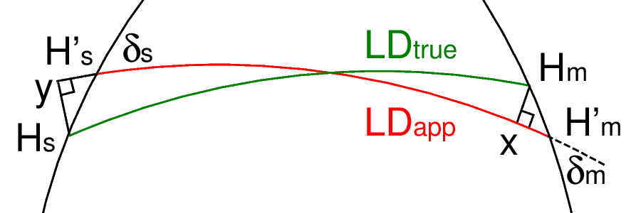
The Merrifield method is based on the fact that the mentioned corrections can be calculated from the small triangles H'm-x-Hm and H's-y-Hs, which can be approximated as plain triangles. The solution of these triangles requires two new variables: δm and δs, but it allows to formulate the true Lunar Distance in a compact form: LDtrue = LDapp + [(H'm - Hm)*cos(δm) + (H's - Hs)*cos(δs)] In which the part in the square brackets [..], can be interpreted as the combined correction for parallax and refraction for both the Moon and the Sun (or another reference object). Notice that this combined correction term can be positive as well as negative (basically depending on the value of the Moon parallax). The δ values can be calculated from the spherical triangle H's-Z-H'm using the law of cosines for the sides: cos(90°-H'm) = cos(LDapp) * cos(90°-H's) + sin(LDapp) * sin(90°-H's) * cos(δs)which can be re-formulated as: cos(δs) = [ cos(90°-H'm) - cos(LDapp) * cos(90°-H's) ] / [ sin(LDapp) * sin(90°-H's) ]
= [ sin(H'm) - cos(LDapp) * sin(H's) ] / [ sin(LDapp) * cos(H's)]
similar:
cos(δm) = [ sin(H's) - cos(LDapp) * sin(H'm) ] / [ sin(LDapp) * cos(H'm)] If a calculator with trigonometric functions is available, this is a most direct way of clearing the measured Lunar Distance from the effects of parallax and refraction. If the calculations have to be performed with trigonometric and logarithmic tables, the Merrifield approximation leads to a calculation scheme similarly complicated as the method of de Borda (or many other). ConclusionWith the above described methods, a result for the true Lunar Distance at the moment of observation is obtained. The final step is to find the Greenwich Mean Time of the occurrence of this observed true Lunar Distance from the recorded values of the pre-computed Lunar Distance Tables. Obtaining Greenwich Time from the Lunar Distance Tables
The final step to determine Greenwich Mean Time is to evaluate the Lunar Distance Tables.
The Tables must be inspected to find the exact time at which the observed true Lunar Distance
for the reference object occurs. Current Position from Lunar Distance MeasurementAfter obtaining the Greenwich Mean Time, the Altitude measurements for the Moon and the reference object can be used to work out two Lines of Position and thus the current position can always be obtained simultaneously with the Greenwich Mean Time. Pre-computed Lunar Distance TablesTables with pre-computed Lunar Distances for different reference objects used to be part of Nautical Almanacs up to early 1900. They allowed to compare cleared Lunar Distances from observations with recorded values and obtain Greenwich Mean Time from this comparison. Selecting the Reference ObjectThe celestial reference bodies recorded in the daily pages of the tables are selected from the following objects: the Sun, the Planets and the brightest stars along the path of the Moon on the celestial sphere. This is the order of preference. Ideally, the reference object should have the same Declination as the Moon, but since this is usually not the case a certain amount of Declination mismatch must be allowed. From a rough analytical analysis, it can be concluded, that a Declination difference can be tolerated if the GHA distance is significantly larger than the Declination difference.
The stars generally recommended for the lunar distance method are Sirius, Aldebaran, Altair, Antares, Fomalhaut, Hamal, Markab, Pollux, Procyon, Betelgeuze, Riegel, Regulus, and Spica, but other stars close to the ecliptic may be used as well, e. g., Enif.
Sources
1.
"The New and Complete Epitome of Practical Navigation" written by J. W. Norie (1828):
2. "The Mathematics of the Longitude" written by Wong Lee Nah (National University of Singapore 2000-2001). 3. "About Lunars" written by George Huxtable (2002) 4. "From the Sailings to Lunar Distances" written by Joel Silverberg (Roger Williams University Bristol, Rhode Island USA 2006) |
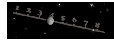 The Moon orbits the Earth in 27.3 days relative to the stars and it's position as seen from
the Earth, changes by about 13° a day or 33' per hour.
So, although the Moon rotates from East to West as does the rest of the Celestial Sphere,
the Moon is lagging this motion a little bit, making it "creep" slowly West to East compared
to the background stars. In this sense, the position of the Moon relative to
the celestial background, can be thought of as similar to the position of the hands of a clock
relative to the dial and the current position of the Moon might be used to determine time similar as
"reading" a chronometer.
The stars along the Ecliptic would simply be the clock dial in the case of this "moon clock".
The Moon orbits the Earth in 27.3 days relative to the stars and it's position as seen from
the Earth, changes by about 13° a day or 33' per hour.
So, although the Moon rotates from East to West as does the rest of the Celestial Sphere,
the Moon is lagging this motion a little bit, making it "creep" slowly West to East compared
to the background stars. In this sense, the position of the Moon relative to
the celestial background, can be thought of as similar to the position of the hands of a clock
relative to the dial and the current position of the Moon might be used to determine time similar as
"reading" a chronometer.
The stars along the Ecliptic would simply be the clock dial in the case of this "moon clock".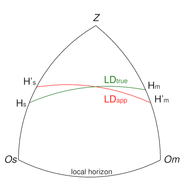
| Cover << Sail Away << Celestial Navigation << Special Techniques << . | last updated: 07-Jan-2020 |