Time
 |
|
Time is essential to celestial navigation in its present form.
The celestial bodies used as reference, are changing their apparent
position in the sky in a continuous but predictable way.
So while doing celestial observations and measuring the Altitude
of celestial objects, the exact time of the measurement does matter!
Roughly estimated - in tropical latitudes - an error of one
second will result in a position error of 0.25 nautical mile (500 meter).
|
Therefore, an accurate board chronometer is a basic instrument
for the celestial navigation.
The Beagle (Charles Darwin's ship) carried 22 watches on board
when she went around the globe in 1830.
Up until the 18th century when John Harrison developed the first
prototype chronometer in 1720, no nautical instruments were available
to "keep time" with a reasonable amount of accuracy.
And until very recently, no earth-bound methods of time keeping
could match the accuracy of time determinations derived from
observations of the Sun and the Planets.
Our natural experience of time is particularly caused by the periodicity of astronomical phenomena:
a year caused by the Earth's orbit around the Sun and the resulting run of the seasons,
a month based on the motion of the Moon around the Earth and the change of the Moon phases,
a day as the period of the Earth's rotation and the succession of day and night.
Already in ancient times people tried to put some order in their domestic lifes and
with the beginning of agriculture, a prediction of seasons was essential for survival.
So, it is not surprising that time keeping and construction of calendars
are among the oldest branches of astronomy.
Time and the Longitude Problem
Before the invention of accurate clocks, it was
nearly impossible for sailors to find their exact Longitude and thus to
find their exact position.
In the days of Christopher Columbus and Francis Drake, Longitude could only
be determined by "dead reckoning", estimating the travelled distance and direction.
But this method was very not precise. Inaccurate sand glasses were used to determine
travelling speed and travelled distance. Moreover the effect of magnetic deviation was
not fully known until the 16th century, so also the travelled direction inherited
a significant amount of inaccuracy.
If the local times at two points on Earth is known,
the time difference is a measure to how far apart those points are in Longitude,
East or West. This idea was very important to sailors and navigators throughout
the centuries. They could measure the local time, wherever they were, by
observing the Sun, but navigation required that they also know the time at
some reference meridian, typically the Prime Meridian of Greenwich, in order
to calculate their Longitude.
The only practical method for determining Longitude
up to the 17th century was the method of timing lunar eclipses. The time
of the eclipse for the reference meridian could be calculated in advance.
Anyone who could observe this eclipse no matter of his position, would also
exactly know the time at the reference meridian. This method had been in
use since ancient times, but since eclipses are rare, it is of limited use.
Although accurate pendulum clocks existed in the
17th Century, the motions of a ship and changes in humidity and temperature
would prevent such a clock from keeping accurate time at sea as required
for navigation.
In 1675 King Charles II founded the Royal Observatory
in Greenwich to solve the problem of finding Longitude at sea.
The Greenwich astronomers first started to elaborate the following idea:
if an accurate catalogue of the positions of the stars and the Moon could
be made, and the position of the Moon relative to the stars could be measured accurately
then by comparing this measured position with the compiled position of the catalogue,
the Greenwich Time at the moment of the observation could be determined.
So, the Moon's motion would be used as a natural clock to "measure" Greenwich
Time from the position of the Moon relative to the background stars.
This means of finding Longitude was known as the Lunar Distance Method.
Although this method was already discussed in the 16th century, the lack of
accurate ephemeral data on the Moon, poor instruments, and the complexity
of the necessary computations, prevented a breakthrough. Nonetheless in 1769-1770
Captain James Cook charted New Zealand with remarkable accuracy determining
his longitudes only by lunar distances.
With the invention of the chronometer, by John Harrison
in the early 18th century and it's further development, the accurate determination
of Longitude was finally possible in a very simple way.
The work of the Royal Observatory in England and
the developments in astronomy, led to increasingly accurate ephemeral data.
In 1767 the English Nautical Almanac appeared. It compiled astronomical
data collected by the Royal Observatory in a single source, and was developed
specially for nautical navigation. This also established the Meridian of
Greenwich as the Prime Meridian for measuring Longitude.
Because the ephemeral data from the Nautical Almanacs
from the Royal Observatory was based on the local Greenwich time, the use
of the Nautical Almanacs anywhere else on the world, also required a precise
knowledge of the Greenwich (local) Time. Therefore the chronometers used
for navigation on board of the military and mercantile vessels using the
publications of the Royal Observatory would show Greenwich Time.
In the 19th century the Greenwich Mean Time
(GMT) was introduced as a time basis for Nautical Almanacs world wide. In
the 20th century this GMT was replaced by the Universal Time (UT).
The time used in the Nautical Almanacs today is UT1 (see below).
Solar Time and Mean Solar Time
Until the 19th century, most European countries, even individual towns, used to the local
solar time for their civil time keeping. The local solar time was based on a simple but
well-defined astronomical measurement with a sundial.
Sundials were positioned so that they indicated 12 o'clock, when the Sun was seen directly
South (on the northern hemisphere), that is at the moment of Local Noon.
The daily time scale was then adjusted such that 12 o'clock of this scale
and Local Noon happened at the same time instance.
For many centuries civil time in the world was entirely based on this Solar Time.
But by the end of the 19th century with the development of extended railway systems,
the need for a more "synchronized" system of time keeping emerged.
Solar Time
The most natural "appearance of Time" is caused by the rotation of
the Earth and the succession of day and night.
Solar time follows this apparent revolution of the Sun around the Earth.
A solar day is the interval between two successive passages of the Sun through the Local Meridian.
Because in the course of a day, the Earth also travels a considerable part of its orbit around the Sun,
a complete rotation with respect to the Sun lasts longer than a complete rotation with respect
to the stars (sidereal day). Consequently, a solar day is longer by about 4 minutes than a
sidereal day. A solar year and a sidereal year differ by one day.
A sundial displays the true solar time at its location,
with Local Noon occurring if the gnomon cast a shadow that is parallel to the Local Meridian
(North-South direction). Because the duration of the solar day (and thus the duration of a solar hour)
varies over the seasons, the time before and after the 12'o clock noon line can only be roughly indicated.
This variation is a consequence both of the eccentricity of the Earth's orbit and the obliquity of the ecliptic
(the tilt of Earth's rotation axis):
The Earth moves at different speeds in different parts
of its elliptical orbit, according to Kepler's second law, hence the sun seems
to move at different speeds along the sky. Even with a perfectly circular Earth orbit, the Sun would
move evenly along the ecliptic but its projection onto the celestial equator would move
at varying speeds. In spring and autumn, the Sun is close to the crossing
points of ecliptic and celestial equator. Its movement from day to day therefore
is slanted to the equator, the projected velocity is thus reduced. During
summer and winter, however, the Sun is close to a vertex of the ecliptic
and moves parallel to the celestial equator, making the projected velocity
larger.
|

|
Both effects result in a variation of the length of a solar day
over the seasons, with the shortest day (24 hours - 21.3 seconds) occurring around
September 16th and the longest solar day (24 hours + 29.9 seconds) occurring around
Decemper 22nd.
Mean Solar Time
To obtain a more uniform time scale, a fictitious
"Mean Sun" is defined. This Mean Sun takes the same time from one vernal
equinox to the next as the true Sun, but it is supposed to move with constant
velocity along the celestial equator.
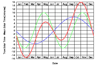
"Equation of Time" |
The time difference between
True and Mean Solar Time is called the "Equation of Time" and recorded over
the year, it takes the form of the red curve
sketched on the left.
The green curve is the deviation
of True and Mean Solar Time due to the obliquity of the ecliptic and the
blue curve represents the effect
of the eccentricity of the Earth's orbit.
Because the two overlapping effects have different time scales
(the eccentricity causes a period of one year, the obliquity of the ecliptic
one of half a year), the Equation of Time (shown red)
has two minima and two maxima per year (near Feb 12, May 15, Jul 27 and Nov 4).
The maximum difference between True and Mean Solar Time is
about 16 minutes (near Feb 12 and Nov 4).
Around Apr 16, Jun 15, Sep 1 and Dec 25 the True and Mean Solar Time are
identical. The Equation of Time is zero for these days.
|
The difference between the True and Mean Solar Time
can also be obtained from the Nautical Almanac. Besides the ephemerides
for each day of the year, the almanac also gives the culmination time of
the Sun for the Prime Meridian of Greenwich (which is always around 12'o
clock UTC). The difference between the Greenwich culmination time
of the Sun and 12'o clock UTC for a specific day, is the value
of the "Equation of Time" for that day.
Universal Time (UT) and Atomic Time (TAI)
The Mean Solar Time is the averaged True Solar
time over the year making this time scale more uniform by eliminating the
effects of the non-uniform revolution of the Earth around the Sun. Based
on this Mean Solar Time is a civil time scale called Universal Time (UT).
|
UT |
Universal Time (UT) was introduced in the year 1926 to replace the
Greenwich Mean Time (GMT). UT is a time scale based on the apparent motion
of the "mean" sun with respect to the Prime Meridian of Greenwich.
UT is only determined by the rotation of the Earth and thus it is affected
by the small irregular and unpredictable variations of the Earth rotation.
There are actually a couple of variants of UT. UT as determined by actual
astronomical observations at a particular observatory is known as UT0
("UT-zero"). It is affected by the motion of the Earth's
rotation pole with respect to the crust of the Earth. UT0 corrected
for this effect yields UT1, which is a measure of the true angular orientation
of the Earth in space. However, because the Earth does not spin at an exact
constant rate, UT1 is not a uniform time scale. The variation in UT1 is dominated
by seasonal oscillations due primarily to the exchange of angular momentum
between the atmosphere and the solid earth and seasonal tides.
In an effort to derive a more uniform time scale, scientists established
UT2. UT2 is obtained from UT1 by applying an adopted formula that approximates
the seasonal oscillations in the Earth's rotation. However, due to other
variations including those associated with the secular effects of tidal friction
(the Earth's spin is continually but gradually slowing down), high frequency
tides and winds, and the exchange of angular momentum between the Earth's
core and its shell, UT2 is also not a uniform time scale.
The Rapid Service/Prediction Center of the
International Earth Rotation
Service (IERS), located at the U.S. Naval Observatory in Washington, monitors the
Earth's rotation. Part of its mission involves the determination of a time
scale based on the current rate of the rotation of the Earth.
|
Eventually, all "natural" time scales based on the
rotation of the Earth will suffer from non-uniform and even non-predictable
irregularities of the motion of the Earth such as the effects of precession
and nutation, the effect of the tides and even atmospheric phenomena.
Therefore, as the demands on the precision of
time references increased during the first half of the 20th century, especially
for experiments related to physics and relativity theory, scientists started
to created a high-precision measure of time, independent of any astronomical
phenomena and highly reproducible.
|
TAI |
This development finally resulted
in the definition of a "standard second", now called "SI second"
after it was embedded in the International System of Measures ("Système
International d'Unités" or short "SI"). The SI second
is in fact derived from and realized with an extremely stable Caesium-133
based frequency reference:
"the SI second is the duration of 9.192.631.770 periods of the radiation
corresponding to the transition between the two hyperfine levels of the ground
state of the Caesium 133 atom"
As of January, 2002, the latest implementation of the primary
Ceasium standard was capable of keeping time to about 30 billionths of a
second per year.
Today, Atomic Time or TAI ("Temps Atomic
International") is the international time standard for science and
civil time keeping. The unit interval TAI is exactly one SI second at mean
sea level. The origin of TAI is such that TAI was approximately UT1 (the
universal time based on the rotation of the Earth) on 1 January 1958.
TAI is calculated continuously by the
Bureau International de Poids et Mesures
(BIPM) from the readings of more than 200 atomic clocks located in meteorological
institutes and observatories in more than 30 countries around the world.
The BIPM estimates that TAI does not lose or gain with respect to an imaginary
perfect clock by more than about one tenth of a microsecond (0.0000001 second)
per year.
Also as physicists were examining astro-dynamic phenomena
with increasing precision, the need for an absolute uniform time scale emerged.
In the course of scientific progress in the second half of the 20th century
different such time scales were introduced.
Modern astro-dynamical theories are based on a smoothly increasing
and uniform time scale known as Terrestrial Time (TT). TT is based
on the same time scale as TAI but "offset" by 32.184 seconds: TT=TAI+32.184s.
However, apparent positions of celestial bodies as calculated for the pages
of the Nautical Almanac are based on the UT time scale bound to the
earth rotation. The difference between TT and UT called "Delta T" is
used to link the two time scales involved:
- the uniform TT for the astro-dynamical calculations
- the UT time scale for the earth-bound astronomical observations:
Delta T = TT-UT1 = TAI-UT1 + 32.184 sec = (TAI-UTC)
- (UT1-UTC) + 32.184 sec
Provisional daily Delta T values can be obtained from the
predicted (UT1-UTC) values listed in
the IERS Bulletin A issued bi-monthly by the Earth Orientation Department
of the US Naval Observatory. The value (TAI - UTC)
is the current number of leap seconds introduced since 1972
(see below).
|
Universal Time Coordinated (UTC)
Universal Time Coordinated (UTC) is a human invention
just as TAI is. Both UTC and TAI are based on the SI second but instead
of TAI, UTC is not a "continuous" time scale. TAI and UTC differ
from each other by an integral number of seconds.
UTC can be seen as the link between the earth-rotation-bound time
scale of UT and the atomic clock based TAI. It is relatively easy to
manufacture highly precise clocks that will keep TAI or UTC, while
the only "clock" keeping UT precisely is the Earth itself.
|
UTC |
Civil time keeping today is not based any more on the rotation of the Earth
but rather on Atomic Time (TAI) kept by time laboratories around the world.
The length of a "reference" day in the TAI and UTC time scale is
defined by the duration of 24x60x60 = 86400 atomic seconds (SI seconds).
This length of the day corresponds to a "mean" day as given by the Earth's
rotation around the year 1900.
But because of the variations in the Earth's spin, the length of the actual
day can be shorter or longer than the nominal day of 86400 seconds.
Since Atomic Time in not directly related to any astronomical
phenomena, the TAI time scale drifts against the UT time scale. However,
it is preferable, that the time scale for civil time keeping will differ
not too much from the time scale determined by the rotation of the Earth
(UT). For this purpose, the concept of a coordinated universal time
was introduced in 1960. The UTC time scale is also based on the atomic second
but "corrected" every now and again by exactly one SI second to keep
it in approximate synchronization with the Earth's rotation (UT).
By international agreement, UTC is not permitted to differ from UT by more
than 0.9 second. In order to keep the cumulative difference in UT1-UTC less
than 0.9 seconds, a leap second is inserted periodically in the atomic UTC time
scale to decrease the difference between the two.
This leap second can be either positive or negative depending on the Earth's
rotation. Since the first leap second in 1972, all leap seconds have been
positive (go to ftp://maia.usno.navy.mil/ser7/leapsec.dat
for a list of all announced leap seconds). This reflects the general slowing
trend of the Earth rotation due to tidal braking.
As of Jan 2009, the last leap second was introduced in the UTC system on
Dec 31, 2008 at 24:00:00.
|
UTC is the time distributed by standard radio
stations that broadcast time signals. It can also be obtained readily from
the Global Positioning System (GPS) satellites. The difference between UTC
and UT1 is made available electronically (Internet) and broadcast so that
navigators can obtain UT1.
For practical Celestial Navigation the UTC time
as distributed by radio stations is a good enough approximation of the UT1
time used in the Nautical Almanacs.
The time difference between both scales of time
- by definition - is smaller than 0.9 seconds. As of Oct 2001, the UTC time
is lagging the UT1 time by 0.1sec. More up-to-date information on this can
be found in the latest issue of the
IERS Bulletin A reports of the
International Earth Rotation Service
(look for the value "DUT1" in the first lines of the report).
Time Zones
Until the 19th century, most European countries,
even individual towns, used to indicate the local time on the basis of a
well-defined astronomical measurement with a sundial. However in the modern
society emerging in the 19th century, it was recognized that it is not very
practical, to have different time indications across a country. Also, there
should not be too many different time zones on a continent.
So in 1894, the countries of Europe agreed to synchronize
their watches (this means that they all show the same time), and to use
a unified indication of time. Since then, in continental Europe, with a
few exceptions, it is no longer necessary to correct your watch when passing
from one country to another. All countries use the same time, which is referred
to as Central European Time (CET).
Similar changes are made in many other regions of
the Earth. The establishment of world time zones accounts for the fact that
for any given moment of the day, the Sun is rising in one place on the Earth,
is standing high in the South at noon for another place and is setting for
a third place. Two places 15° of Longitude apart, have one hour difference
in local Solar Time. Considering these astronomical facts, it makes sense
to use different civil time scales at different places on the Earth.
Principally the earth is divided into 24 Time Zones
and each Time Zone extends over 15° of Longitude. All places within
the same Time Zone will use the same time called Local Time corresponding
to the Mean Solar Time of the central Meridian of the Time Zone.
The Local Time of a Time Zone usually differs by
an integral number of hours from Universal Time (UT), although sporadically
other differences occur. For Time Zones East of Greenwich the Local Time
leads Universal Time whereas the Local Time of Time Zones west of Greenwich
lag Universal Time.
The Time Zone, which adopts UT as Local Time is principally centred
on the Prime Meridian of Greenwich (from 7.5°E to 7.5°W).
Ultimately, the adoption of a Local Time scale
is a political decision and is therefore handled differently in individual
countries. More information on which Local Time is used in the different
countries around the world can be found at
http://worldtimezone.com/.
The current Date and Time situation in the different Time Zones
and at the Date Line, can be seen in the
Time-Zones Window.
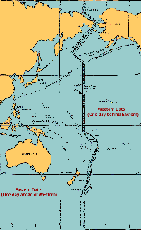
International Date Line
The International Date Line is the imaginary
line on the Earth that separates two consecutive calendar days. The date
in the eastern hemisphere (to the left of the line), is always one day ahead
of the date in the western hemisphere. The International Date Line has been
adopted as a matter of convenience and has no force in international law.
|
Without the International Date Line
travellers going westward would discover that when they returned home, one
day more than they thought had passed, even though they had kept careful
record of the elapsed days. This first happened to Magellan's crew after
the first circumnavigation of the globe (although this "circumnavigation's
paradox" was already known since the 13th century).
Likewise, a person travelling eastward would find that one day less had elapsed
than he had recorded, as happened to Phileas Fogg in
"Around the World in Eighty Days" by Jules Verne.
The International Date Line can be anywhere on the globe.
But it is most convenient to be 180° away from the Prime Meridian that
goes through Greenwich, England. It also is fortunate that this area is covered,
mainly, by empty ocean.
Over the years, the position of the International Date Line has changed
several times. Until 1845, the Philippines were East of the Date Line (the
same side as the United States). It was on the eastern side because as a Spanish
colony most Europeans arrived there via the Spanish colonies in South America.
At the same time, Indonesia, which is almost directly to the South of the
Philippines, was West of the Date Line because it was a Dutch colony and
most European arrivals came via the Cape of Good Hope.
|
After the independence of the South American countries, most
people travelling to the Philippines also came by way of the Cape of Good
Hope, so it was decided to change from the East of the Date Line to the West
of the Date Line.
Alaska, originally claimed by Russia, was to the West of the
Date Line because most travellers arrived there by way of Siberia. When the
United States bought Alaska in 1867 the Date Line was moved to the East of it.
The most recent change in the International Date Line was in 1995 when Kiribati
moved a large segment of it to the East, so that the entire nation would be on
the same side of the Date Line.
As with all other changes in the International Date Line, this change was made
by a local government to allow for local circumstances. As a result, the Date Line
is as far East as E 150°, farther East than Honolulu.
The current Date and Time situation in the different Time Zones
and at the Date Line, can be seen in the
Time-Zones Window.
|